
Tsunami warnings throughout the Pacific, as far away a US west coast. Some pretty dramatic videos. The Twitter video a few posts down in the 2nd link of the sound of the blast is insane, sounds like a bomb went off. What's truly impressive are the satellite images of the shock wave as it spreads. This was a very powerful event
https://news.google.com/stories/CAAqNgg ... id=US%3Aen
https://twitter.com/JTuisinu/status/148 ... gr%5Etweet
Moderators: richierich, ua900, PanAm_DC10, hOMSaR
Large Volcanic eruption near Tonga
Last edited by SQ22 on Sun Jan 16, 2022 7:29 am, edited 1 time in total.
Reason: Title updated
Reason: Title updated
-
- Thunderboltdrgn
- Posts: 2622
- Joined:
Re: Large Volcanic eruption near Tonga
A few videos with satellite footage + regular footage + tsuanmis hitting shore (unspecified location). Looks like a very big blow.
https://www.youtube.com/watch?v=ouMTT9ikKWY
https://www.youtube.com/watch?v=yIn9ZqWG1xg
https://www.youtube.com/watch?v=Eu8V_WADjCw
https://www.youtube.com/watch?v=ouMTT9ikKWY
https://www.youtube.com/watch?v=yIn9ZqWG1xg
https://www.youtube.com/watch?v=Eu8V_WADjCw
-

- BN727227Ultra
- Posts: 811
- Joined:
Tonga volcano puts ash up to 100K ft.:
Hunga-Tonga-Hunga-Ha’apai! Preliminary interpretations of satellite data by educated hobbyists suggest it might be as big as Pinatubo in 1991. I could imagine US West Coast-AU/NZ might be affected as well as regional.
-

- GalaxyFlyer
- Posts: 12400
- Joined:
Re: Tonga volcano puts ash up to 100K ft.:
Here’s a link to the Wellington VAAC for alerts on aviation ash hazards.
http://vaac.metservice.com/dynamic/wellington.html
http://vaac.metservice.com/dynamic/wellington.html
-
- casinterest
- Posts: 16972
- Joined:
Re: Large Volcanic eruption near Tonga
Thunderboltdrgn wrote:A few videos with satellite footage + regular footage + tsuanmis hitting shore (unspecified location). Looks like a very big blow.
https://www.youtube.com/watch?v=ouMTT9ikKWY
https://www.youtube.com/watch?v=yIn9ZqWG1xg
https://www.youtube.com/watch?v=Eu8V_WADjCw
That last video is impressive, The episode half way through with the lightning was incredible.
Re: Tonga volcano puts ash up to 100K ft.:
I think there were a few planes in the sky within 500km or so at the time. Curious if they noticed the pressure wave

Re: Tonga volcano puts ash up to 100K ft.:
Halophila wrote:I think there were a few planes in the sky within 500km or so at the time. Curious if they noticed the pressure wave
It was noticeably measurable when it arrived in Anchorage, AK some 7 hours after the event (travel speed was around 834mph)
-
- smokeybandit
- Posts: 1924
- Joined:
Re: Tonga volcano puts ash up to 100K ft.:
The pressure wave was measured all across the USA
Re: Large Volcanic eruption near Tonga
The Twitter video by Chris Combs about halfway down the page in this link is a longer version of the one in a link posted earlier. The reaction of the people in the video conveys the sense of shock and panic when the blast wave hit. As loud a it was I am sure they felt as well as heard it
https://futurism.com/satellite-footage-volcano-erupting
https://futurism.com/satellite-footage-volcano-erupting
-

- CostaDelSol90
- Posts: 54
- Joined:
Re: Tonga volcano puts ash up to 100K ft.:
Multiple services in an out of NAN already cancelled…
Re: Large Volcanic eruption near Tonga
Have been interested in volcanoes since childhood. For an event this size with a summit/crater collapse I’m always a little confused: does the explosion trigger the collapse or other way around? I suppose it could go either way. And regardless a tsunami will be triggered by debris moving swiftly underwater.
In any case should be a dramatic next few days with more Surtseyan blasts.
In any case should be a dramatic next few days with more Surtseyan blasts.
-
- CostaDelSol90
- Posts: 54
- Joined:
Re: Tonga volcano puts ash up to 100K ft.:
Make that all Fiji airways and Virgin Australia flights in and out. QF only ones trying at this stage.
Re: Tonga volcano puts ash up to 100K ft.:
New Zealand is slightly lucky that the boarder is largely closed still, as it is Public Summer School holidays so would have caused chaos.
NZ946 seems to have made an pretty normal routing to RAR this morning from AKL.
https://www.flightradar24.com/ANZ946/2a82221b
NZ946 seems to have made an pretty normal routing to RAR this morning from AKL.
https://www.flightradar24.com/ANZ946/2a82221b

Re: Tonga volcano puts ash up to 100K ft.:
BN727227Ultra wrote:Hunga-Tonga-Hunga-Ha’apai! Preliminary interpretations of satellite data by educated hobbyists suggest it might be as big as Pinatubo in 1991. I could imagine US West Coast-AU/NZ might be affected as well as regional.
Potentially two years of cooler temperatures if it's Pinatubo sized.
-

- Aresxerexade
- Posts: 634
- Joined:
Re: Tonga volcano puts ash up to 100K ft.:
Do we know yet if the plume is affecting or is going to affect the US Hawaiian island air traffic?

Re: Tonga volcano puts ash up to 100K ft.:
Flights between Fiji and Australia have resumed, with delays averaging three to four hours.
-
- 45272455674
- Posts: 7732
- Joined:
Re: Large Volcanic eruption near Tonga
That was a big blast.
We had tsunami warnings here in Sydney, some beaches were closed and people were advised to go to higher ground and keep away from the immediate coastal areas. Japan also recorded it and issued their usual prompt alerts.
We had tsunami warnings here in Sydney, some beaches were closed and people were advised to go to higher ground and keep away from the immediate coastal areas. Japan also recorded it and issued their usual prompt alerts.

Re: Large Volcanic eruption near Tonga
We had some boats damaged up the coast from us in Winchester Bay and there were others damaged in Sausalito and along Lost Coast in Mendocino County.
I wonder, though:
This is the second tsunami I have been coastal for. SFO, OAK, YVR, JNU, HNL and OTH are right on the water. Many others, too. What is the procedure for tsunamis at these airports? In general? I know every airport is different, but, in general, what is the procedure? Warning incoming flights, moving equipment, and so on?
-

- Francoflier
- Posts: 6554
- Joined:
Re: Large Volcanic eruption near Tonga
DIRECTFLT wrote:https://apnews.com/article/media-environment-and-nature-new-zealand-tonga-d434936e25079859df8261780976def8
Tonga Bat Volcano
Scott Manley's got a video out showing sat pictures before and afer a previous, smaller eruption that happened just before the big one, where we can see that the isthmus between the two rocky headlands had already been destroyed...
It'll be interesting to see what it looks like after the dust (ash) settles, and I'm guessing it will look nothing like before. The power of these events is unimaginable.
https://www.youtube.com/watch?v=zoMRwyNhqJ4
Re: Large Volcanic eruption near Tonga
Francoflier wrote:DIRECTFLT wrote:https://apnews.com/article/media-environment-and-nature-new-zealand-tonga-d434936e25079859df8261780976def8
Tonga Bat Volcano
Scott Manley's got a video out showing sat pictures before and afer a previous, smaller eruption that happened just before the big one, where we can see that the isthmus between the two rocky headlands had already been destroyed...
It'll be interesting to see what it looks like after the dust (ash) settles, and I'm guessing it will look nothing like before. The power of these events is unimaginable.
https://www.youtube.com/watch?v=zoMRwyNhqJ4
The popping of Earth zits is definitely a sight to behold
-
- Thunderboltdrgn
- Posts: 2622
- Joined:
Re: Large Volcanic eruption near Tonga
Japan was hit by a tsunami with wave heights of about 1.2-1.2 meters.
https://www.japantimes.co.jp/news/2022/ ... a-volcano/
Also per UAF Geophysical Institute on twitter the eruption was heard in Alaska
https://twitter.com/UAFGI/status/1482448811901345794
Tokyo/Wellington – Japan's Pacific coast was hit early Sunday by tsunami waves following a massive underwater volcanic eruption in the South Pacific the previous day, prompting the weather agency to issue tsunami warnings and advisories. Nearly 230,000 residents were urged to move to high ground.
The Meteorological Agency at one point early Sunday issued a tsunami warning for the northeastern prefecture of Iwate and the southwestern islands of Amami and Tokara in Kagoshima Prefecture, predicting waves as high as 3 meters, but later downgraded the warnings to advisories.
All the advisories were revoked by 2 p.m. Sunday.
A 1.2-meter tsunami was observed in the city of Amami shortly before midnight Saturday, while a 1.1-meter tsunami arrived in Kuji, Iwate, at 2:26 a.m. Sunday.
According to the agency, a small tsunami of less than 1 meter was observed across a wide area of the country's Pacific coast, from Hokkaido to Kyushu and Okinawa.
There were no immediate reports of injuries.
https://www.japantimes.co.jp/news/2022/ ... a-volcano/
Also per UAF Geophysical Institute on twitter the eruption was heard in Alaska
Info from David Fee, @Alaska_AVO
coordinating scientist re #Tonga volcano eruption: A part of the pressure signal in Alaska was in the audible range. The very large signal is not
that surprising considering the scale of the eruption, but the audible aspect is fairly unique.
https://twitter.com/UAFGI/status/1482448811901345794
-
- MohawkWeekend
- Posts: 2781
- Joined:
Re: Large Volcanic eruption near Tonga
Wonder if the Chinese airfields they just built on sandbars are underwater?
Re: Large Volcanic eruption near Tonga
MohawkWeekend wrote:Wonder if the Chinese airfields they just built on sandbars are underwater?
That would seem unlikely with the Philippines and Indonesia in the way.
Re: Large Volcanic eruption near Tonga
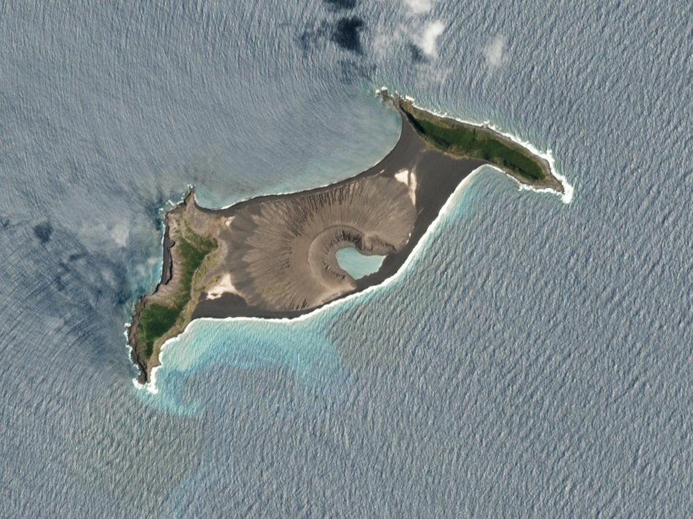
As we have had a tsunami, the magma chamber has collapsed again. So pretty sure, there is no middle island any more, will be intersting to see, if the both outer edge islands are still there or also gone now/are now part of the new formed calderra structure. Just remind, the whole vulcano is part of a calderra.
-
- MohawkWeekend
- Posts: 2781
- Joined:
Re: Large Volcanic eruption near Tonga
Aaron747 wrote:MohawkWeekend wrote:Wonder if the Chinese airfields they just built on sandbars are underwater?
That would seem unlikely with the Philippines and Indonesia in the way.
Wouldn't want anyone hurt but 2 feet of water may have changed their mind. Oh well.
Re: Large Volcanic eruption near Tonga
T4thH wrote:As we have had a tsunami, the magma chamber has collapsed again. So pretty sure, there is no middle island any more, will be intersting to see, if the both outer edge islands are still there or also gone now/are now part of the new formed calderra structure. Just remind, the whole vulcano is part of a calderra.
A radar image captured by Sentinel-1 is already available.
https://twitter.com/CopernicusEU/status ... 9038394370
Outer edge islands much smaller than before, nothing but water inbetween.
-
- BN727227Ultra
- Posts: 811
- Joined:
Re: Large Volcanic eruption near Tonga
Aaron747 wrote:Have been interested in volcanoes since childhood. For an event this size with a summit/crater collapse I’m always a little confused: does the explosion trigger the collapse or other way around? I suppose it could go either way. And regardless a tsunami will be triggered by debris moving swiftly underwater.
In any case should be a dramatic next few days with more Surtseyan blasts.
Downthread imagery is posted that shows the collapse before the 15 January eruption. Not all eruptions are the same, certainly not all caldera-forming ones. Ma Nature is a hoot.
Re: Large Volcanic eruption near Tonga
Aaron747 wrote:Have been interested in volcanoes since childhood. For an event this size with a summit/crater collapse I’m always a little confused: does the explosion trigger the collapse or other way around? I suppose it could go either way. And regardless a tsunami will be triggered by debris moving swiftly underwater.
In any case should be a dramatic next few days with more Surtseyan blasts.
I am not a geologist not volcanologist but after most major eruptions the ejected magma leaves a void that the rest of the volcano collapses into. Volcanic structures are not strong rocks but a lot of new sediments on top of each other that don't have a lot of structural strength such as a rock like Granite that takes millions of years to get that density and strength.
It is theorized that the super calderas (Toba, Yellowstone, Lake Taupo) were formed because the surrounding rocks collapsed into the void.
I say most eruptions because if you look at Mt. St Helens. The Northern flank was blown off from a landslide and it was a horizontal blast
There is a really good docudrama Supervolcano and many documentaries on big eruptions. They discovered this be doing modeling from what is known about the 1883 Krakatoa eruption as the volcanic island was gone.
Re: Large Volcanic eruption near Tonga
Noray wrote:T4thH wrote:As we have had a tsunami, the magma chamber has collapsed again. So pretty sure, there is no middle island any more, will be intersting to see, if the both outer edge islands are still there or also gone now/are now part of the new formed calderra structure. Just remind, the whole vulcano is part of a calderra.
A radar image captured by Sentinel-1 is already available.
https://twitter.com/CopernicusEU/status ... 9038394370
Outer edge islands much smaller than before, nothing but water inbetween.
Thanks for the link to the image. So we have there now a new calderra with the size of around 3 to 3,5 km diameter (minimum). And the center seems to be south of the former middle part of the island and of the vent, so more in the direction of the center of the "original" old big calderra. The northern edge of the whole calderra structure is now a little bit extended.
-
- Thunderboltdrgn
- Posts: 2622
- Joined:
Re: Large Volcanic eruption near Tonga
One missing and two drowned after the volcano tsunami.
A British woman was out swimming with her husband when the tsunami hit Tonga and she is now missing,
https://www.theguardian.com/world/2022/ ... s-for-news
In Peru two people drowned when the tsunami hit the coast of Peru.
https://www.theguardian.com/world/2022/ ... -hit-coast
A British woman was out swimming with her husband when the tsunami hit Tonga and she is now missing,
“The tsunami hit around 5.30pm local time, I believe,” said Eleini. “Angela and her husband, James, got washed away. James was able to cling on to a
tree for quite a long time, but Angela was unable to do so and was washed away with the dogs, I think four or five dogs.
https://www.theguardian.com/world/2022/ ... s-for-news
In Peru two people drowned when the tsunami hit the coast of Peru.
Two people have drowned off a beach in northern Peru, local authorities say, after unusually high waves were recorded in several coastal
areas following Saturday’s eruption of an underwater volcano in Tonga.
The deaths occurred on Saturday on a beach located in the Lambayeque region, Peru’s National Institute of Civil Defence (Indeci) said in a statement.
https://www.theguardian.com/world/2022/ ... -hit-coast
Re: Large Volcanic eruption near Tonga
StarAC17 wrote:It is theorized that the super calderas (Toba, Yellowstone, Lake Taupo) were formed because the surrounding rocks collapsed into the void.
I say most eruptions because if you look at Mt. St Helens. The Northern flank was blown off from a landslide and it was a horizontal blast
That's right - the USGS later theorized that internally parts of the Mt. St. Helens north flank had become substantially weakened by water intrusion and this is what spurred the cryptodome's growth to massively disfigure the summit area so rapidly in March/April 1980 perior to the eruption.

Source: USGS
Re: Large Volcanic eruption near Tonga
Hunga Tonga Volcano Eruption Update
https://youtu.be/hYvThiDk-iU
GeologyHub
The Hunga Tonga-Hunga Ha'apai volcano in Tonga on January 15th produced a large and destructive tsunami through a new volcanic eruption. This tsunami occurred due to partial edifice collapse, which destroyed the vast majority of the existing island. Instead of a once 4 kilometer or 2.4 mile wide island, there are now only two small barrier islands. What had just occurred was likely the most powerful volcanic eruption in a decade. This video will separate fact from fiction, and discuss the eruption, what its true magnitude is, and what might happen next at Hunga Tonga. It is a very famous volcano as it has produced several spectacular island forming eruptions in the 21st century.
Re: Large Volcanic eruption near Tonga
If one wants to geek out on this and other eruptions, then the Volcano Cafe website is the place for you. Some of the posts are quite technical, but there is so much to read and to see that is just plain fascinating. The hundreds of videos and pics posted there from YouTube, Twitter, private posts, etc. are great, and the comments section contains posts that follow the events in real time. Here is a link to the latest activity from Hunga Tonga . . .
https://www.volcanocafe.org/the-vei-5-m ... nga-tonga/
https://www.volcanocafe.org/the-vei-5-m ... nga-tonga/
Re: Large Volcanic eruption near Tonga
SkyVoice wrote:If one wants to geek out on this and other eruptions, then the Volcano Cafe website is the place for you. Some of the posts are quite technical, but there is so much to read and to see that is just plain fascinating. The hundreds of videos and pics posted there from YouTube, Twitter, private posts, etc. are great, and the comments section contains posts that follow the events in real time. Here is a link to the latest activity from Hunga Tonga . . .
https://www.volcanocafe.org/the-vei-5-m ... nga-tonga/
That's Excellent !! Thanks for the link.
Tonga calls for 'immediate aid' as another large eruption detected
https://www.youtube.com/watch?v=DzDN-1Z9vqM
Re: Large Volcanic eruption near Tonga
SkyVoice wrote:If one wants to geek out on this and other eruptions, then the Volcano Cafe website is the place for you. Some of the posts are quite technical, but there is so much to read and to see that is just plain fascinating. The hundreds of videos and pics posted there from YouTube, Twitter, private posts, etc. are great, and the comments section contains posts that follow the events in real time. Here is a link to the latest activity from Hunga Tonga . . .
https://www.volcanocafe.org/the-vei-5-m ... nga-tonga/
One of my favorite websites by far


Re: Large Volcanic eruption near Tonga
OK, odd question but which aircraft are best able to fly in heavy ash conditions?
Tugg
Tugg
Re: Large Volcanic eruption near Tonga
Tugger wrote:OK, odd question but which aircraft are best able to fly in heavy ash conditions?
Tugg
None. Especially turbine powered aircraft.
Re: Large Volcanic eruption near Tonga
Tugger wrote:OK, odd question but which aircraft are best able to fly in heavy ash conditions?
Tugg
Maybe Hot Air Balloons
Re: Large Volcanic eruption near Tonga
DIRECTFLT wrote:Tugger wrote:OK, odd question but which aircraft are best able to fly in heavy ash conditions?
Tugg
Maybe Hot Air Balloons
Actually melted ash might clog the flame emitter
Re: Large Volcanic eruption near Tonga
Aaron747 wrote:DIRECTFLT wrote:Tugger wrote:OK, odd question but which aircraft are best able to fly in heavy ash conditions?
Tugg
Maybe Hot Air Balloons
Actually melted ash might clog the flame emitterNot to mention ash frozen to the balloon exterior would significantly add to the weight of the vehicle.
 Nevermind...
Re: Large Volcanic eruption near Tonga
Tugger wrote:OK, odd question but which aircraft are best able to fly in heavy ash conditions?
Tugg
Gliders. And you might get some nice thermals above the volcano, too.
Re: Large Volcanic eruption near Tonga
DIRECTFLT wrote:SkyVoice wrote:If one wants to geek out on this and other eruptions, then the Volcano Cafe website is the place for you. Some of the posts are quite technical, but there is so much to read and to see that is just plain fascinating. The hundreds of videos and pics posted there from YouTube, Twitter, private posts, etc. are great, and the comments section contains posts that follow the events in real time. Here is a link to the latest activity from Hunga Tonga . . .
https://www.volcanocafe.org/the-vei-5-m ... nga-tonga/
That's Excellent !! Thanks for the link.
Tonga calls for 'immediate aid' as another large eruption detected
https://www.youtube.com/watch?v=DzDN-1Z9vqM
I didn't realize that this was a VEI 5 eruption.
For those who don't know a lot about Volcanism, this is about equivalent to the 1980 Mt. St. Helens eruption. The land that was there likely did collapse back into the ocean which is the most likely cause of the Tsunami
https://en.wikipedia.org/wiki/Volcanic_ ... vity_Index
Yikes! wrote:Tugger wrote:OK, odd question but which aircraft are best able to fly in heavy ash conditions?
Tugg
None. Especially turbine powered aircraft.
Don't be under a lot of distress if you do.
Signed,
Eric Moody
I don't know why I had to make a corny BA 009 joke but that is probably the most well known incident of a jetliner flying into volcanic ash.
The 40th anniversary of that incident is coming up in June.
Re: Large Volcanic eruption near Tonga
Thanks all. I realize the weirdness of the question. I know planes don't like ash, more importantly any engine really!
Wasn't sure if some brainchild had come up with a filter system that could work.
(I can only think of a rotating one that blocks it as it comes in then continuously rotates so that is blown off and clear filter space is presented. But I get the impossibly/difficulty of that being made to work.)
Tugg
Re: Large Volcanic eruption near Tonga
Aaron747 wrote:DIRECTFLT wrote:Tugger wrote:OK, odd question but which aircraft are best able to fly in heavy ash conditions?
Tugg
Maybe Hot Air Balloons
Actually melted ash might clog the flame emitter
And we shall not forget the hundred of thousands of lighning strikes during the eruption. The job as grilled balloon driver is no so funny...

Re: Large Volcanic eruption near Tonga
Tugger wrote:Thanks all. I realize the weirdness of the question. I know planes don't like ash, more importantly any engine really!
Wasn't sure if some brainchild had come up with a filter system that could work.
(I can only think of a rotating one that blocks it as it comes in then continuously rotates so that is blown off and clear filter space is presented. But I get the impossibly/difficulty of that being made to work.)
Tugg
The issue with volcanic ash is that its both incredibly fine as a particle but also very abrasive as it is rock at its most microscopic level. Its essentially vaporized glass and I don't know how effective any filtration would work that would be beneficial to an jet engine in normal operations. You would need a HEPA filter to essentially filter out the stuff. Wouldn't make sense considering that satellites know exactly where the Ash is. Thankfully most volcanoes are out of frequently traveled air routes. Iceland is in a particularly bad spot for the North Atlantic routes.
If you go back to BA 009, the leading edges of the 747 were sandblasted because it is an abrasive material. Also the melting point of Ash is around lower than the combustion chamber of a jet and it causes all kinds of chaos.
Re: Large Volcanic eruption near Tonga
StarAC17 wrote:Tugger wrote:Thanks all. I realize the weirdness of the question. I know planes don't like ash, more importantly any engine really!
Wasn't sure if some brainchild had come up with a filter system that could work.
(I can only think of a rotating one that blocks it as it comes in then continuously rotates so that is blown off and clear filter space is presented. But I get the impossibly/difficulty of that being made to work.)
Tugg
The issue with volcanic ash is that its both incredibly fine as a particle but also very abrasive as it is rock at its most microscopic level. Its essentially vaporized glass and I don't know how effective any filtration would work that would be beneficial to an jet engine in normal operations. You would need a HEPA filter to essentially filter out the stuff. Wouldn't make sense considering that satellites know exactly where the Ash is. Thankfully most volcanoes are out of frequently traveled air routes. Iceland is in a particularly bad spot for the North Atlantic routes.
If you go back to BA 009, the leading edges of the 747 were sandblasted because it is an abrasive material. Also the melting point of Ash is around lower than the combustion chamber of a jet and it causes all kinds of chaos.
Indeed, it is pretty cool stuff. If you have never held a handful of the stuff, I recommend it. I had the opportunity at a volcano museum in Japan.
Re: Tonga volcano puts ash up to 100K ft.:
For Volcano geeks.
The full movie is on YouTube. This is a Canadian/British docudrama on what a Yellowstone super eruption would do to the US and the world.
It's a full out movie but factual.
https://youtu.be/WFaFfdOzPP8
It was a VEI 5. Equivalent to Mt. St. Helens. It might drop temps 0.1-0.2 degrees C. I have to remember where I read that. It also depends on how much Sulfur Dioxide was in the eruption. That is the gas that reflects sunlight.
Pinatubo was a VEI 6.
Like the Richter scale each jump represents a 10 fold increase of material ejected. It was 10x the strength of Mt. St Helens.
Mt. Tambora which caused the year without a summer in 1813-1814 IIRC was a VEI 7. 10 times Pinatubo at minimum.
The full movie is on YouTube. This is a Canadian/British docudrama on what a Yellowstone super eruption would do to the US and the world.
It's a full out movie but factual.
https://youtu.be/WFaFfdOzPP8
ssteve wrote:BN727227Ultra wrote:Hunga-Tonga-Hunga-Ha’apai! Preliminary interpretations of satellite data by educated hobbyists suggest it might be as big as Pinatubo in 1991. I could imagine US West Coast-AU/NZ might be affected as well as regional.
Potentially two years of cooler temperatures if it's Pinatubo sized.
It was a VEI 5. Equivalent to Mt. St. Helens. It might drop temps 0.1-0.2 degrees C. I have to remember where I read that. It also depends on how much Sulfur Dioxide was in the eruption. That is the gas that reflects sunlight.
Pinatubo was a VEI 6.
Like the Richter scale each jump represents a 10 fold increase of material ejected. It was 10x the strength of Mt. St Helens.
Mt. Tambora which caused the year without a summer in 1813-1814 IIRC was a VEI 7. 10 times Pinatubo at minimum.
Re: Large Volcanic eruption near Tonga
I wish the NZ or Aust. Govt. would parachute drop in a squad to asses what's going on on the main Island.
Who is online
Users browsing this forum: No registered users and 43 guests