Moderators: richierich, ua900, PanAm_DC10, hOMSaR
-

- FlyDeltaJets
- Posts: 1659
- Joined:
CRJ GPS Issues
Anyone hearing about a nationwide CRJ200/700 navigation issue that is causing delays across all airlines?
Last edited by atcsundevil on Mon Jun 10, 2019 11:04 am, edited 1 time in total.
Reason: Title updated
Reason: Title updated
-
- Mountainman11
- Posts: 4
- Joined:
Re: CRJ200/700 GPS Transponder Issue?
There is an issue with an unknown cause currently. It is also affecting the CRJ900. There is also a report of at least one 737-900 and a 767.
Re: CRJ200/700 GPS Transponder Issue?
Seems to be all CRJs and some B739s.
-
- 1989worstyear
- Posts: 887
- Joined:
Re: CRJ200/700 GPS Transponder Issue?
Could this be something to do with the GPS update recently?
Re: CRJ200/700 GPS Transponder Issue?
Hawaiian started having issues on the 717 fleet at 00z today.
Re: CRJ200/700 GPS Transponder Issue?
It's any airplanes with Rockwell Collins GPS installed. It includes all CRJs and A220s. DL had issues with some 739s and 757s, and HA had some issues on their 717s.
I believe only the bombardier aircraft can operate with a MEL.
DL had at least one diversion SJC-ATL that went to MEM because of it.
I believe only the bombardier aircraft can operate with a MEL.
DL had at least one diversion SJC-ATL that went to MEM because of it.
Re: CRJ200/700 GPS Transponder Issue?
Not all CRJs. Just moved us from a 700 to a 200. Not yet boarded.
-
- CRJ200flyer
- Posts: 372
- Joined:
Re: CRJ200/700 GPS Transponder Issue?
I was supposed to operate out of Atlanta last night on a CRJ-200. The issue first started for us when we were descending into Atlanta in the early evening. Later that evening trying to depart, it became apparent the issue was impacting hundreds of aircraft. We delayed over four hours, and finally canceled. Maintenance can defer on the CRJ with an MEL, but it takes time to get around to every aircraft and get approval for each one to operate from ATC. Atlanta was a total mess on top of the multiple rounds of storms that had already hit the airport all day.
ATL Cancellations:
Yesterday - 131
Today (so far) - 30
ATL Cancellations:
Yesterday - 131
Today (so far) - 30
Last edited by CRJ200flyer on Sun Jun 09, 2019 3:08 pm, edited 2 times in total.
-
- CRJ200flyer
- Posts: 372
- Joined:
Re: CRJ200/700 GPS Transponder Issue?
GPS Outage Map
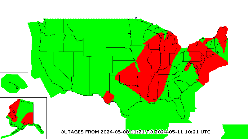
Moderators - please adjust the title to something like “US GPS Outage” as this issue is still ongoing and affecting many aircraft types across many carriers.
Moderators - please adjust the title to something like “US GPS Outage” as this issue is still ongoing and affecting many aircraft types across many carriers.
-

- fotoflyer71
- Posts: 41
- Joined:
Re: CRJ200/700 GPS Transponder Issue?
CRJ200flyer wrote:GPS Outage Map
Moderators - please adjust the title to something like “US GPS Outage” as this issue is still ongoing and affecting many aircraft types across many carriers.
The map you have displayed isn't a GPS Outage Map - it appears to be the RAIM summary for NPA.
-
- Mountainman11
- Posts: 4
- Joined:
Re: CRJ200/700 GPS Transponder Issue?
FAA put out a blanket exemption for aircraft suffering this issue. Still no concrete answer on why it is occurring.
ATCSCC ADVZY 030 DCC 06/09/2019 GUIDANCE FOR GPS/ADS-B ANOMALIES
MESSAGE:
EVENT TIME: 09/1240 - 10/0400
COMMAND CENTER HAS APPROVED BLANKET WAIVER FOR ALL FLIGHTS
CURRENTLY
HAVING GPS/ADS-B ISSUES WITH THEIR TRANSPONDERS. INDIVIDUAL WAIVER
REQUESTS TO THE COMMAND CENTER ARE NO LONGER NECESSARY. HOWEVER,
AFFECTED FLIGHTS SHOULD FILE FLIGHT PLANS VIA THE FOLLOWING
PARAMETERS:
YOU MUST FILE FL280 AND BELOW. YOU MUST FILE RNAV ROUTING AND IF
YOU
ARE UNABLE,YOU MUST FILE VIA TRADITIONAL AIRWAYS AND/OR NAVAIDS.
THIS BLANKET APPROVAL IS VALID ONLY UNTIL JUNE 10, 0400Z.
EFFECTIVE TIME:
091242 - 100430
SIGNATURE:
19/06/09 12:42
Re: CRJ200/700 GPS Transponder Issue?
Looks like Mesa is really struggling to cope.
Has anyone heard anything from Rockwell Collins on the matter yet?
Has anyone heard anything from Rockwell Collins on the matter yet?
-
- Weatherwatcher1
- Posts: 1317
- Joined:
Re: CRJ200/700 GPS Transponder Issue?
kabq737 wrote:Looks like Mesa is really struggling to cope.
Has anyone heard anything from Rockwell Collins on the matter yet?
Do you have any information on what the impact is on Mesa?
Re: CRJ200/700 GPS Transponder Issue?
Weatherwatcher1 wrote:kabq737 wrote:Looks like Mesa is really struggling to cope.
Has anyone heard anything from Rockwell Collins on the matter yet?
Do you have any information on what the impact is on Mesa?
This is unconfirmed as it is just word of mouth but I am told that they are unable to MEL GPS more than one flight in a row. That’s just what I was told though.
-
- Mountainman11
- Posts: 4
- Joined:
Re: CRJ200/700 GPS Transponder Issue?
kabq737 wrote:Weatherwatcher1 wrote:kabq737 wrote:Looks like Mesa is really struggling to cope.
Has anyone heard anything from Rockwell Collins on the matter yet?
Do you have any information on what the impact is on Mesa?
This is unconfirmed as it is just word of mouth but I am told that they are unable to MEL GPS more than one flight in a row. That’s just what I was told though.
Same information I have heard as well.
-
- triple3driver
- Posts: 130
- Joined:
Re: CRJ200/700 GPS Transponder Issue?
Jeez, I remember the Rockwell Collins systems as being pretty reliable, surprising. But yeah, we're having quite a few issues with the Boeings and CRJs at JFK, loads of delays and cancellations from what I understand, guess I'll see for myself when I get back to work tomorrow.
Re: CRJ200/700 GPS Transponder Issue?
https://www.fly.faa.gov/adv/adv_otherdi ... e=06/09/19
ATCSCC ADVZY 029 DCC 06/09/2019 GUIDANCE FOR ADSB
MESSAGE:
EVENT TIME: 09/1230 - 10/0400Z
COMMAND CENTER HAS APPROVED BLANKET WAIVER FOR ALL FLIGHTS CURRENTLY
HAVING GPS/ADSB ISSUES WITH THEIR TRANSPONDERS. INDIVIDUAL WAIVER
REQUESTS TO THE COMMAND CENTER ARE NO LONGER NECESSARY. HOWEVER,
AFFECTED FLIGHTS SHOULD FILE FLIGHT PLANS VIA THE FOLLOWING
PARAMETERS:
YOU MUST FILE FL280 AND BELOW. YOU MUST FILE RNAV ROUTING AND IF YOU
ARE UNABLE,YOU MUST FILE VIA TRADITIONAL AIRWAYS AND/OR NAVAIDS.
THIS BLANKET APPROVAL IS VALID ONLY UNTIL JUNE 10, 0400Z.
EFFECTIVE TIME:
091231 - 100430
SIGNATURE:
19/06/09 12:31
ATCSCC ADVZY 108 DCC 06/09/2019 PRE COORDINATION OF NON TRANSPONDER EQUIPPED AIRCRAFT
MESSAGE:
EVENT TIME: 09/2305 - 10/1700
THIS ADVISORY CANCELS AND REPLACES ADVISORY 104 TO CORRECT THE
SPELLING OF SUFFIX IN THE ORIGINAL ADVISORY.
ISSUE: CURRENTLY CERTAIN AIRCRAFT EQUIPPED WITH THE ROCKWELL
COLLINS
GPS 4000-100 AND SELECT ADS-B OUT GPS RECEIVERS ARE INDICATING
"ADS-B FAIL, UNAVAILABLE, TCAS FAIL OR TRANSPONDER FAIL" MESSAGES.
THE FAA COMMAND CENTER (DCC) IS SUSPENDING PRE COORDINATION WITH
DCC
OF THOSE AIRCRAFT IMPACTED BY THE ROCKWELL COLLINS GPS ISSUE THAT
HAVE WORKING TRANSPONDERS.
AIRCRAFT WITHOUT WORKING TRANSPONDERS MUST STILL COORDINATE AS PER
DIRECTIVE.
AIRCRAFT MUST FILE THE APPROPRIATE EQUIPMENT SUFFIX CONSISTENT WITH
THE AIRCRAFT CAPABILITY TO ENSURE ACCESS TO RVSM AIRSPACE.
UPDATES WILL BE PROVIDED AS NECESSARY
EFFECTIVE TIME:
092307 - 111730
SIGNATURE:
19/06/09 23:07
-

-
atcsundevil
Moderator
- Posts: 6130
- Joined:
Re: CRJ GPS Issues
I have moved this thread to Civil Aviation because of the fairly significant impacts of these issues.
-
- Weatherwatcher1
- Posts: 1317
- Joined:
Re: CRJ GPS Issues
The issue appears to go well beyond CRJs
https://www.forbes.com/sites/zakdoffman ... ad99933878
Hundreds of flights affected
Various online reports suggested impacted planes were mostly CRJ jets made by Canada’s Bombardier, but also some Boeing 737s, 717s and possibly a 767 as well. "We are working to determine the cause of the problem," the FAA said in a statement, "which may have resulted from a software update to the aircraft navigation systems."
https://www.forbes.com/sites/zakdoffman ... ad99933878
Hundreds of flights affected
Re: CRJ GPS Issues
UA in ASE was a mess saturday evening and sunday morning with cancellations due to GPS problems.
Re: CRJ GPS Issues
Good thing we just transitioned too the new gps based Q Routes...
Re: CRJ GPS Issues
Hawaiian quickly recovered and operated as normal on Sunday.
Re: CRJ GPS Issues
The more complicated you make a system,...............
Re: CRJ GPS Issues
So Let me get this straight. Nobody knows how to Navigate using the High and Low charts?? REALLY? INS Direct is cool and SAT NAV is cooler but if you can't fly VOR Nav? Then your piloting skills are Lacking
Re: CRJ GPS Issues
strfyr51 wrote:So Let me get this straight. Nobody knows how to Navigate using the High and Low charts?? REALLY? INS Direct is cool and SAT NAV is cooler but if you can't fly VOR Nav? Then your piloting skills are Lacking
It's not that pilot skills are lacking, it's that MEL restrictions and routings may restrict operations. When suddenly hundreds of aircraft throughout the system need MEL applications and routings must be changed to J or V routes, operations are going to be impacted.
Re: CRJ GPS Issues
strfyr51 wrote:So Let me get this straight. Nobody knows how to Navigate using the High and Low charts?? REALLY? INS Direct is cool and SAT NAV is cooler but if you can't fly VOR Nav? Then your piloting skills are Lacking
What’s a VOR?

Re: CRJ GPS Issues
N766UA wrote:strfyr51 wrote:So Let me get this straight. Nobody knows how to Navigate using the High and Low charts?? REALLY? INS Direct is cool and SAT NAV is cooler but if you can't fly VOR Nav? Then your piloting skills are Lacking
What’s a VOR?
A VOR is a ground based radio navigation beacon. They were the back bone of the airspace system from the 1950s through the 90s/00s. Now with how reliable GOS has been, the FAA is decommissioning VORs and not quickly fixing broken VORs.
Unfortunately when over 500 airline aircraft suddenly break, the paperwork takes a
while. When all those aircraft also looses the ability to use GPS, and need to use only the working VORs, the airspace gets very jammed up.
Re: CRJ GPS Issues
I was flying an A319 yesterday and had the same issues.
Re: CRJ GPS Issues
strfyr51 wrote:So Let me get this straight. Nobody knows how to Navigate using the High and Low charts?? REALLY? INS Direct is cool and SAT NAV is cooler but if you can't fly VOR Nav? Then your piloting skills are Lacking
Wow what a ridiculous statement.
Do your research before criticizing trained professionals. It isn't that the pilots can't fly VORs it's all about MEL issues and getting operating approval. The pilots have no issues with "flying the green needles" it's a matter of getting approval to do so.
-
- GalaxyFlyer
- Posts: 12408
- Joined:
Re: CRJ GPS Issues
Can’t say for the CRJ, but the same system in a Challenger just reverted to DME-DME for RNAV which I would guess should work over the US for enroute and some terminal navigation. But, obviously, it’s more complicated than that.
BTW, I’ve flown with newbies who I wonder could fly VOR navigation. It’s not difficult, but if you’ve never done it, it’s different.
BTW, I’ve flown with newbies who I wonder could fly VOR navigation. It’s not difficult, but if you’ve never done it, it’s different.
Re: CRJ GPS Issues
GalaxyFlyer wrote:Can’t say for the CRJ, but the same system in a Challenger just reverted to DME-DME for RNAV which I would guess should work over the US for enroute and some terminal navigation. But, obviously, it’s more complicated than that.
BTW, I’ve flown with newbies who I wonder could fly VOR navigation. It’s not difficult, but if you’ve never done it, it’s different.
CRJ is the same. It flies just fine without GPS.
Like others have said, it isnt that the crews/plane cannot do it. Its a HUGE paperwork issue.
-
- DiamondFlyer
- Posts: 3835
- Joined:
Re: CRJ GPS Issues
bradyj23 wrote:GalaxyFlyer wrote:Can’t say for the CRJ, but the same system in a Challenger just reverted to DME-DME for RNAV which I would guess should work over the US for enroute and some terminal navigation. But, obviously, it’s more complicated than that.
BTW, I’ve flown with newbies who I wonder could fly VOR navigation. It’s not difficult, but if you’ve never done it, it’s different.
CRJ is the same. It flies just fine without GPS.
Like others have said, it isnt that the crews/plane cannot do it. Its a HUGE paperwork issue.
The blanket FAA waiver specifically prohibits RNAV routes and restricts altitude to FL280 and below
Re: CRJ GPS Issues
kabq737 wrote:strfyr51 wrote:So Let me get this straight. Nobody knows how to Navigate using the High and Low charts?? REALLY? INS Direct is cool and SAT NAV is cooler but if you can't fly VOR Nav? Then your piloting skills are Lacking
Wow what a ridiculous statement.
Do your research before criticizing trained professionals. It isn't that the pilots can't fly VORs it's all about MEL issues and getting operating approval. The pilots have no issues with "flying the green needles" it's a matter of getting approval to do so.
I'M not criticizing Pilots, but Sat Nav can be "Hacked" and it may BE being Hacked as we speak. the VOR was at least reliable and pretty much Un-Hackable as they were Ground Based We're going down a rabbit hole focusing only on it. Satellite Nav is good, But we have seen the effects when it doesn't work!! and we have NO Backup.
And? I was a Pilot though I trained before Sat Nav became the" be al to end all" . I've got 5500 Hours in total though I can no longer fly as I lost sight in my left eye so now I'm a passenger..
-
- FlyingElvii
- Posts: 3088
- Joined:
Re: CRJ GPS Issues
This is still a major issue today, the current ORD delay program is a direct result. Too many aircraft down low around Chicago. Mesa seems to now have some CRJ's operating above 27/28, but not many. Was SkyWest affected, as well?
-
- FlyingElvii
- Posts: 3088
- Joined:
Re: CRJ GPS Issues
strfyr51 wrote:kabq737 wrote:strfyr51 wrote:So Let me get this straight. Nobody knows how to Navigate using the High and Low charts?? REALLY? INS Direct is cool and SAT NAV is cooler but if you can't fly VOR Nav? Then your piloting skills are Lacking
Wow what a ridiculous statement.
Do your research before criticizing trained professionals. It isn't that the pilots can't fly VORs it's all about MEL issues and getting operating approval. The pilots have no issues with "flying the green needles" it's a matter of getting approval to do so.
I'M not criticizing Pilots, but Sat Nav can be "Hacked" and it may BE being Hacked as we speak. the VOR was at least reliable and pretty much Un-Hackable as they were Ground Based We're going down a rabbit hole focusing only on it. Satellite Nav is good, But we have seen the effects when it doesn't work!! and we have NO Backup.
And? I was a Pilot though I trained before Sat Nav became the" be al to end all" . I've got 5500 Hours in total though I can no longer fly as I lost sight in my left eye so now I'm a passenger..
Another reason why the "New" LORAN system needs to implemented, as quickly as possible.
Re: CRJ GPS Issues
N766UA wrote:strfyr51 wrote:So Let me get this straight. Nobody knows how to Navigate using the High and Low charts?? REALLY? INS Direct is cool and SAT NAV is cooler but if you can't fly VOR Nav? Then your piloting skills are Lacking
What’s a VOR?
Very Old Radio.
-
- FlyingElvii
- Posts: 3088
- Joined:
Re: CRJ GPS Issues
Utah744 wrote:N766UA wrote:strfyr51 wrote:So Let me get this straight. Nobody knows how to Navigate using the High and Low charts?? REALLY? INS Direct is cool and SAT NAV is cooler but if you can't fly VOR Nav? Then your piloting skills are Lacking
What’s a VOR?
Very Old Radio.
Newer than Never Drops Baseball
Re: CRJ GPS Issues
strfyr51 wrote:kabq737 wrote:strfyr51 wrote:So Let me get this straight. Nobody knows how to Navigate using the High and Low charts?? REALLY? INS Direct is cool and SAT NAV is cooler but if you can't fly VOR Nav? Then your piloting skills are Lacking
Wow what a ridiculous statement.
Do your research before criticizing trained professionals. It isn't that the pilots can't fly VORs it's all about MEL issues and getting operating approval. The pilots have no issues with "flying the green needles" it's a matter of getting approval to do so.
I'M not criticizing Pilots, but Sat Nav can be "Hacked" and it may BE being Hacked as we speak. the VOR was at least reliable and pretty much Un-Hackable as they were Ground Based We're going down a rabbit hole focusing only on it. Satellite Nav is good, But we have seen the effects when it doesn't work!! and we have NO Backup.
And? I was a Pilot though I trained before Sat Nav became the" be al to end all" . I've got 5500 Hours in total though I can no longer fly as I lost sight in my left eye so now I'm a passenger..
The way you came off certainly did sound as if you were criticizing pilots.
Can you cite any evidence that the GPS system we know “may BE being hacked as we speak?”
I’m willing to learn but you don’t seem to know what the real issues are here.
Re: CRJ GPS Issues
It wasn’t a GPS issue I believe. Instead it was a software issue with the Rockwell Collins GPS-4000 aircraft that were back fitted with an ADS-B compliant transponder (in order to comply with FAA ADS-B OUT requirements.)
The software issue caused the transponder to fail.
Because it’s a transponder issue, ATC is not allowing affected aircraft into RVSM airspace.
The software issue caused the transponder to fail.
Because it’s a transponder issue, ATC is not allowing affected aircraft into RVSM airspace.
-
- DiamondFlyer
- Posts: 3835
- Joined:
Re: CRJ GPS Issues
Here’s an explanation, from Rockwell Collins that I’ve seen floating around the internet. Not every CRJ is effected, but a large majority seem to be. Obviously planes not yet retrofitted with ADS-B aren’t effected l.
On June 9, 2019, Collins Aerospace received reports that certain GPS and GLU models were not acquiring GPS constellations after power up. The impacted units known at this time are the: GPS-4000S (P/N 822-2189-100) and GLU-2100 (P/N 822-2532-100).
The following aircraft may be equipped with the GPS-4000S - P/N 822-2189-100. Please check your configuration to confirm:
· Bombardier Challenger 300
· Bombardier Challenger 350
· Bombardier Challenger 604
· Bombardier Challenger 650
· Bombardier Global 5000 Vision
· Bombardier Global 6000
· Embraer Legacy 450
· Embraer Legacy 500
· Gulfstream G150
· Gulfstream G280
· Textron CJ3
· Textron Hawker 800XP
Other models with the GPS-4000S - P/N 822-2189-100 will also be impacted.
The root cause is a software design error that misinterprets GPS time updates. A "leap second" event occurs once every 2.5 years within the US Government GPS satellite almanac update. Our GPS-4000S (P/N 822-2189-100) and GLU-2100 (P/N 822-2532-100) software's timing calculations have reacted to this leap second by not tracking satellites upon power-up and subsequently failing. A regularly scheduled almanac update with this “leap second” was distributed by the US Government on 0:00GMT Sunday June 9, 2019 and the failures began to occur after this event.
Please contact your OEM and regulatory authority to obtain an MEL or MEL extension if possible. If you have not powered up your units, leave them off until after June 16, 2019 00:15Z
The next scheduled update by the US Government to the GPS constellation is set for next Sunday June 16 00:00Z. We do not believe this update will include time information which triggers this error, however we are testing for impact of this almanac update.
Best Regards,
Liz Cornell | Dealer/Member Services Support | Avionics
COLLINS AEROSPACE
400 Collins Road, Cedar Rapids, IA 52498 U.S.A
Re: CRJ GPS Issues
Leap Seconds? That makes no sense to me. I'm thinking that is the wrong terminology.
Some basics:
GPS Almanac - Basically a set of information that allows a receiver to know where the gps satellites are without waiting to download that information from the signals the satellites broadcast. Speeds up the time to get an initial position solution if you don't have recent the broadcast ephemeris (position data) on your receiver.
Leap Second - A second added or subtracted from Universal Coordinated Time (UTC). These are only added on June 30 or Dec 31 and there is none scheduled for June (last one was in 2016).
UTC - The time you normally use (basically the same as Greenwich Standard Time) with a timezone offset for wherever you are. Leap seconds are added to keep this time in sync with earth's slowing rotation.
GPS Time - The time a GPS satellite uses. Started in 1980. Does NOT have leap seconds added to it. If you want to get UTC time from GPS time you need to include the number of GPS seconds added since 1/6/1980 when GPS time started (I believe 18).
To me, if it's an issue with some piece of data related to time I would not expect anything to "jump" one week to the next.
For the record the phrase "we do not believe this update will include......" would get me fired if I used that to pray for a fix.
-
- DiamondFlyer
- Posts: 3835
- Joined:
Re: CRJ GPS Issues
zuckie13 wrote:Leap Seconds? That makes no sense to me. I'm thinking that is the wrong terminology.
Some basics:
GPS Almanac - Basically a set of information that allows a receiver to know where the gps satellites are without waiting to download that information from the signals the satellites broadcast. Speeds up the time to get an initial position solution if you don't have recent the broadcast ephemeris (position data) on your receiver.
Leap Second - A second added or subtracted from Universal Coordinated Time (UTC). These are only added on June 30 or Dec 31 and there is none scheduled for June (last one was in 2016).
UTC - The time you normally use (basically the same as Greenwich Standard Time) with a timezone offset for wherever you are. Leap seconds are added to keep this time in sync with earth's slowing rotation.
GPS Time - The time a GPS satellite uses. Started in 1980. Does NOT have leap seconds added to it. If you want to get UTC time from GPS time you need to include the number of GPS seconds added since 1/6/1980 when GPS time started (I believe 18).
To me, if it's an issue with some piece of data related to time I would not expect anything to "jump" one week to the next.
For the record the phrase "we do not believe this update will include......" would get me fired if I used that to pray for a fix.
I'm not one to believe they truly know what the problem is, let alone how to fix it. Don't shoot the messenger, in the mean time, we do what we can operationally.

Re: CRJ GPS Issues
Sounds like an Easter hangover...
https://galileognss.eu/gps-week-number- ... il-6-2019/
Could be the patch, if it was needed, had a bug in it and they rolled out a fix that gave the planes a super bug.
https://galileognss.eu/gps-week-number- ... il-6-2019/
Could be the patch, if it was needed, had a bug in it and they rolled out a fix that gave the planes a super bug.
-
- GalaxyFlyer
- Posts: 12408
- Joined:
Re: CRJ GPS Issues
Collins has been down this trail before, as has Honeywell.
-
- slowrambler
- Posts: 186
- Joined:
Re: CRJ GPS Issues
zuckie13 wrote:Leap Seconds? That makes no sense to me. I'm thinking that is the wrong terminology.
It's correct. Although GPS time does not have leap seconds itself, GPS broadcasts a notification that a leap second is about to happen (which will occur June 30 this year). Apparently the software wasn't tested to handle this information properly. It "jumped" because that's when they switched the notification on.
Re: CRJ GPS Issues
slowrambler wrote:zuckie13 wrote:Leap Seconds? That makes no sense to me. I'm thinking that is the wrong terminology.
It's correct. Although GPS time does not have leap seconds itself, GPS broadcasts a notification that a leap second is about to happen (which will occur June 30 this year). Apparently the software wasn't tested to handle this information properly. It "jumped" because that's when they switched the notification on.
As I said above there is no leap second this June. They are announced 5ish months before they happen. This is the bulletin from IERS who announce it (https://datacenter.iers.org/data/latest ... IN_C16.txt):
"NO leap second will be introduced at the end of June 2019."
-
- slowrambler
- Posts: 186
- Joined:
Re: CRJ GPS Issues
zuckie13 wrote:slowrambler wrote:zuckie13 wrote:Leap Seconds? That makes no sense to me. I'm thinking that is the wrong terminology.
It's correct. Although GPS time does not have leap seconds itself, GPS broadcasts a notification that a leap second is about to happen (which will occur June 30 this year). Apparently the software wasn't tested to handle this information properly. It "jumped" because that's when they switched the notification on.
As I said above there is no leap second this June. They are announced 5ish months before they happen. This is the bulletin from IERS who announce it (https://datacenter.iers.org/data/latest ... IN_C16.txt):
"NO leap second will be introduced at the end of June 2019."
Fair, my bad (it would have been quite late). Nevertheless it's clearly correlated with the GPS almanac and I'm willing to take Rockwell Collins's word that they're misinterpreting it.
Re: CRJ GPS Issues
Hi...for dead reckoning you compute the wind triangle using a compass, additionally you need information about wind speed and true airspeed. Which the compass obviously does not provide.
Anyway, GPS provides heading information anyway, in addition to whatever else information you need, so I am not sure I see the point. You use whatever instruments available to tell you where your are and where you are headed.
Anyway, GPS provides heading information anyway, in addition to whatever else information you need, so I am not sure I see the point. You use whatever instruments available to tell you where your are and where you are headed.
Who is online
Users browsing this forum: AABB777, AaronPGH, AdEd, aerace, amc737, anymaninfc, atrude777, B6SpiritofEWR, baje427, behramjee, Bing [Bot], bx737, Capn, Cerecl, chepos, chrisnh, CONTACREW, crytexx, DalRiada, deltacto, FlyingViking, georgiabill, goCOgo, Google Adsense [Bot], heavymetal, hpff, Iceman7, Isebulu, Jayce, jetblastdubai, jsteeves3, jtt99, jumbojettony, kwbl, LAOCA, LAXdude1023, Lesquin, Maurooo21, mayank28, MD80MKE, mig17, morrisond, N197, NickolayAv, nine4nine, oldJoe, pabloeing, pg747, rduhosen, rising, Rudenko, rumorboy, Runway28L, SFOThinker, Speedalive, SteelChair, sunking737, timf, TUSAA, USPIT10L, Uspurs, VHOGU, VolvoBus and 329 guests